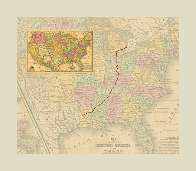
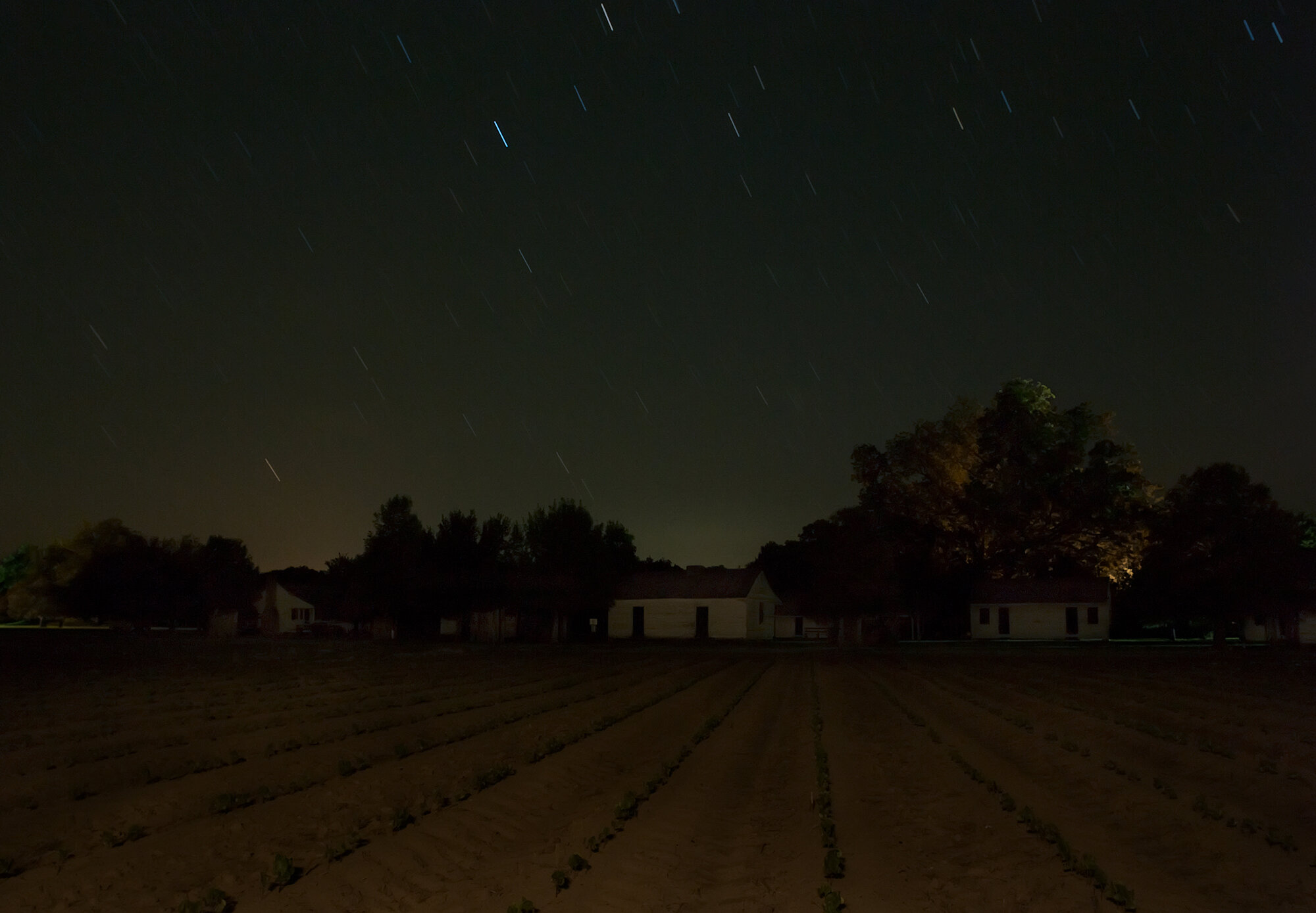
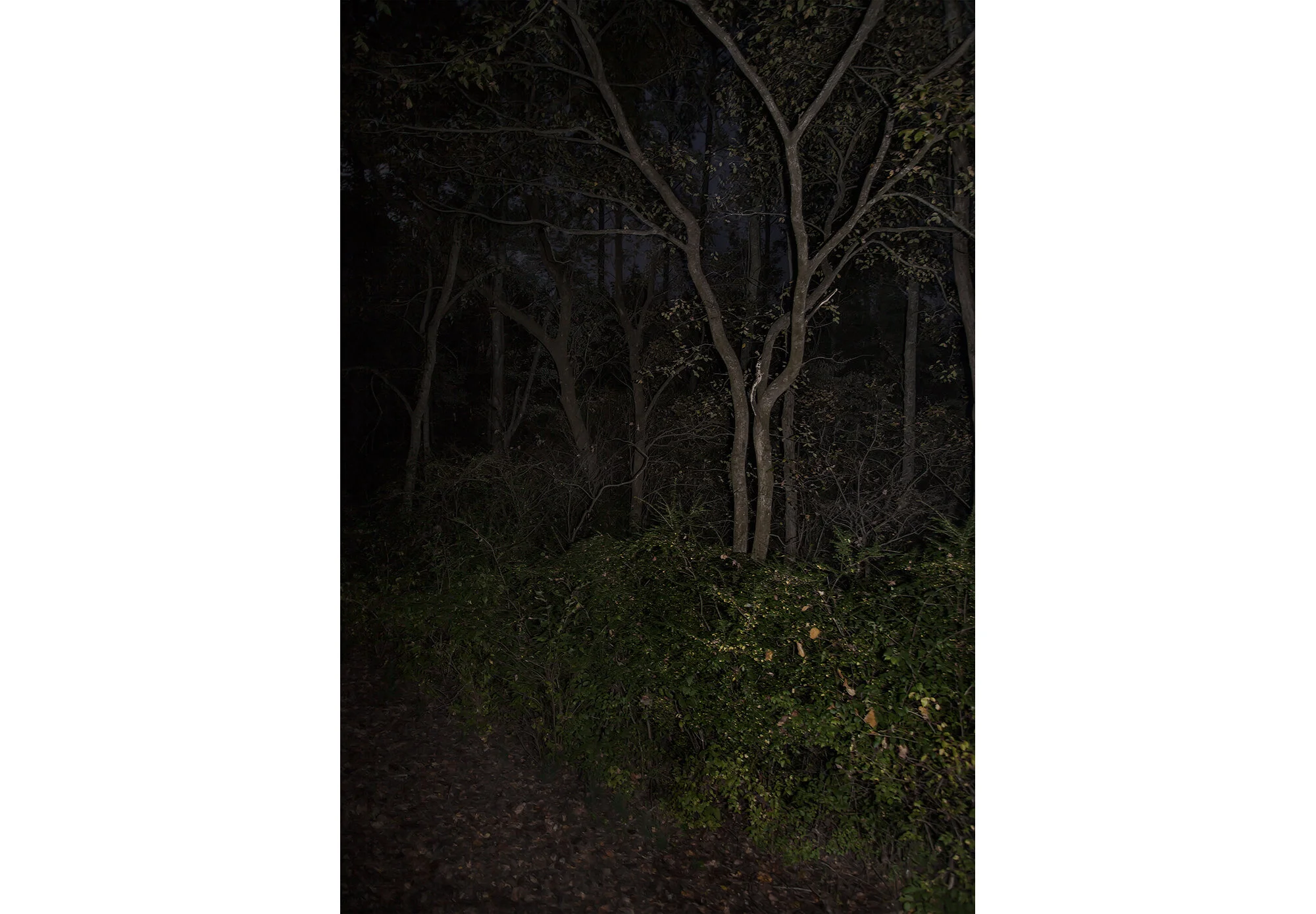
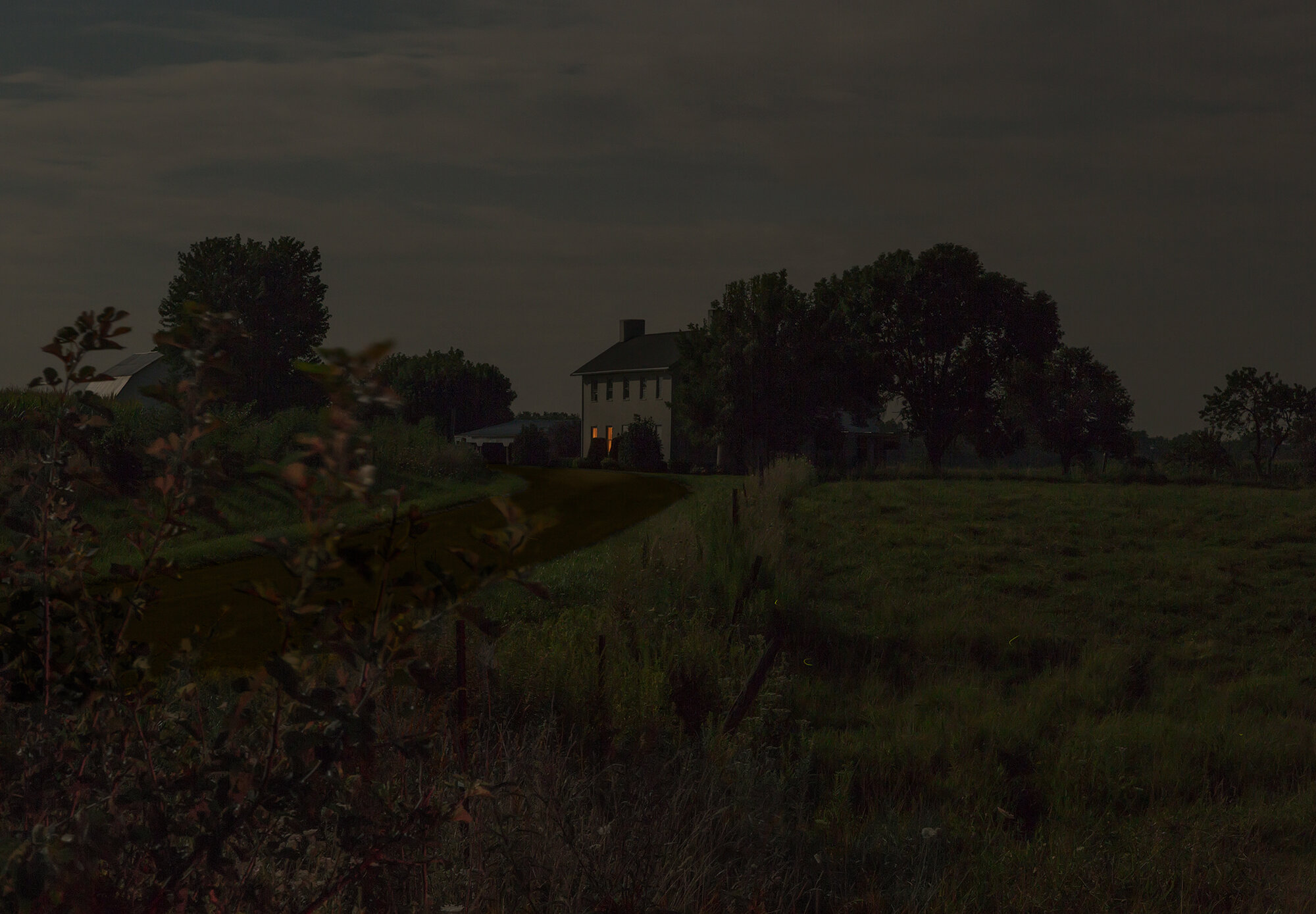
JEANINE MICHNA-BALES
Through Darkness to Light:
Photographs Along the Underground Railroad
Digital C-Prints or Dye Sublimation print on Aluminum
Available in the following sizes:
21 x 28 1/2 in., Edition of 9
30 x 41 in., Edition of 8
View fullsize
The 1,400 mile path from Louisiana to Ontario (Copy)
View fullsize
Through Darkness. 2014
View fullsize
Decision to Leave. Magnolia Plantation on the Cane River, Louisiana, 2013
View fullsize
On the Run. North of the Cane River Plantations, Louisiana, 2013
View fullsize
Wading Prior to Blackness. Grant Parish, Louisiana, 2014
View fullsize
Southern Pine Forest. Following El Camino Real, LaSalle Parish, Louisiana, 2014
View fullsize
Catching a Breath. LaSalle Parish, Louisiana, 2014
View fullsize
Black River Crossing. Continuing along El Camino Real, Catahoula Parish, Louisiana, 2014
View fullsize
Stopover. Frogmore Plantation, Concordia Parish, Louisiana, 2014
View fullsize
Bog. Catahoula Parish, Louisiana, 2014
View fullsize
Gathering Provisions. Outskirts of the Myrtle Grove Plantation, Tensas Parish, Louisiana, 2014
View fullsize
Moonlight Over the Mississippi. Tensas Parish, Louisiana, 2014
View fullsize
Through the Forest. Jefferson County, Mississippi, 2014
View fullsize
Resting Place. Church Hill, Mississippi, 2015
View fullsize
Hiding Out Back. Slave cemetery, Mount Locust Stand and Plantation, Jefferson County, Mississippi, 2014
View fullsize
Sunken Trace. Claiborne County, Mississippi, 2015
View fullsize
Avoiding the Coyotes. Hinds County, Mississippi, 2014
View fullsize
Determining True North in the Rain. Along the southern part of the Old Natchez Trace, Mississippi, 2014
View fullsize
Tracking the Deer. Skirting the Osburn Stand, Mississippi, 2014
View fullsize
Cypress Swamp. Middle Mississippi, 2014
View fullsize
Off the Beaten Path. Along the Yockanookany River, Mississippi, 2014
View fullsize
Following the Trace North. Attala County, Mississippi, 2014
View fullsize
Doubling Back. Webster County, Mississippi, 2015
View fullsize
From Whence We Came. Following Robinson Road, Mississippi, 2014
View fullsize
Stopping for Directions. Meadow Woods Plantation, Oktibbeha, Mississippi, 2014
View fullsize
Crawling Ahead. Chickasaw County, Mississippi, 2014
View fullsize
Crossing Open Space. Lee County, Mississippi, 2014
View fullsize
Keep Going. Crossing the Tennessee River, Colbert County, Alabama, 2014
View fullsize
Through the Underbrush. Along the Old Natchez Trace, southern Tennessee, 2012
View fullsize
Downed Tree. Wayne County, Tennessee, 2014
View fullsize
Twisted Thicket. Lawrence County, Tennessee, 2014
View fullsize
Devil’s Backbone. Lewis County, Tennessee, 2014
View fullsize
Shelter from the Storm. Hickman County, Tennessee, 2014
View fullsize
Tennessee Valley Divide. Williamson County, Tennessee, 2014
View fullsize
Taking to the Hollow. Davidson County, Tennessee, 2014
View fullsize
Hidden in Plain Sight. Rose Mont Plantation, Sumner County, Tennessee, 2014
View fullsize
A Lesson in Astronomy. Southern Kentucky, 2014
View fullsize
Fleeing the Torches. Warren County, Kentucky, 2014
View fullsize
Hidden Passage. Mammoth Cave, Barren County, Kentucky, 2014
View fullsize
Following the Green River. Edmonson County, Kentucky, 2014
View fullsize
Secret Tunnels. Munfordville Presbyterian Church, Munfordville, Kentucky, 2014
View fullsize
Old Man Moon. Hardin County, Kentucky, 2014
View fullsize
Into the Night. Spencer County, Kentucky, 2014
View fullsize
Racing the Stars. Between Oldham and Shelby Counties, Kentucky, 2014
View fullsize
Over the Hills. North Trimble County, Kentucky, 2014
View fullsize
The River Jordan. First view of a free state, crossing the Ohio River to Indiana, 2014
View fullsize
Eagle Hollow from Hunter’s Bottom. Just across the Ohio River, Indiana, 2014
View fullsize
Dr. Lott’s House. Georgetown District of Madison, Indiana, 2013
View fullsize
Woods on the Way to Wirt. Jefferson County, Indiana, 2014
View fullsize
Wade in the Water. Graham Creek in Jennings County, Indiana, 2013
View fullsize
On the Way to the Hicklin House Station. San Jacinto, Indiana, 2013
View fullsize
Follow the Tracks to the First Creek. Just outside Richland, a free black community, Stone Arch Railroad Bridge, Vernon, Indiana, 2013
View fullsize
Follow the Drinking Gourd. Jefferson County, Indiana, 2013
View fullsize
Elias Conwell House. Along Old Michigan Road, a major north-south artery between Kentucky and Michigan, Napoleon, Indiana, 2013
View fullsize
Moonrise Over Northern Ripley County. From the Decatur County line, Indiana, 2013
View fullsize
Nightlight. Passing into Fayette County, Indiana, 2014
View fullsize
Friend or Foe? Station just outside Metamora, Indiana, 2014
View fullsize
Nearing Brookville. Franklin County, Indiana, 2014
View fullsize
A Brief Respite. Abolitionist William Beard’s house, Union County, Indiana, 2014
View fullsize
Go to the House on the Hill. Possible Underground Railroad station, Cambridge City, Indiana, 2013
View fullsize
Look for the Gray Barn Out Back. Joshua Eliason Jr. barnyards and farmhouse, with a tunnel leading under- neath the road to another station, Centerville, Indiana, 2013
View fullsize
A Very Good Road. Drawing near the Bishop Paul Quinn Station, Richmond, Indiana, 2014
View fullsize
A Safe Place to Regroup. House of Levi Coffin, who was unofficially dubbed the president of the Underground Railroad, Fountain City (formerly Newport), Indiana, 2014
View fullsize
Approaching the Seminary. Near Spartanburg, Indiana, 2014
View fullsize
Taking Cover with the Fireflies. North of Winchester, Indiana, 2014
View fullsize
On the Safest Route. James and Rachel Sillivan cabin, Pennville (formerly Camden), Indiana, 2014
View fullsize
Orange Moon. Adams County, Indiana, 2014
View fullsize
Walk Along the Ridge. Between the Maumee and St. Joseph Rivers, Braun-Leslie House, Fort Wayne, Indiana, 2014
View fullsize
Lying Low. William Cornell House, outside Auburn, Indiana, 2014
View fullsize
Queen Anne’s Lace. South Steuben County, Indiana, 2014
View fullsize
Bird’s Eye View. Erastus Farnham House, south of Fremont, Indiana, 2014
View fullsize
Dirt Road. Outside Coldwater, Michigan, 2014
View fullsize
Concealed in the Fog. Near Jonesville, Michigan, 2014
View fullsize
Nearing the Farm. Royal Watkins farmstead, Jackson County, Michigan, 2014
View fullsize
“Liberty to the Fugitive Captive.” Waiting for the all-clear to head to the Captain John Lowry Station, Lodi Plains Cemetery, Nutting’s Corner, Michigan, 2014
View fullsize
Moon Over the “Old Slave House.” Reverend Guy Beckley’s home north of the Huron River, Lower Town, Michigan, 2014
View fullsize
Delayed Arrival. Arthur and Nathan Power Station, Quakertown, Michigan, 2014
View fullsize
Wait for the Call of the Hoot Owl. Oakland County, Michigan, 2014
View fullsize
The Beacon Tree. Spring Hill Farm, Macomb County, Michigan, 2014
View fullsize
A Place of Rest. Rufus Nutting House, Romeo, Michigan, 2014
View fullsize
Within Reach. Crossing the St. Clair River to Canada just south of Port Huron, Michi- gan, 2014
View fullsize
Freedom. Canadian soil, Sarnia, Ontario, 2014